Showing posts with label the loch. Show all posts

Tuesday, June 21, 2016

Taylor Glacier, Powell Peak, Taylor Peak, Otis Peak, Hallett Peak, and Flattop Mountain.

The last time around, I'd written about one of the more difficult glacier/snow climbs in RMNP.  But, of course, there was one more on the list: Taylor Glacier.  Gerry Roach has called this "moderate my ass glacier", and I have seen estimates in the 50-55 degree range, though 60 seems to be most commonly agreed on.  Foster says 60 degrees, AI3.  Rossiter says steep snow, AI2.  The author of this report actually measured low 60's in the higher up sections, and 68 degrees near the top.  That is steep!
Again, I did as much online research as I could, and there are actually a few trip reports out there, and they seem to range the full gamut of human experience.   
This one, which my friend Gary was a part of, is more toward the "this was an awesome life affirming experience".  In this one, a very experienced climber talks about being happy they had a rope along, which they almost didn't bring.  This one calls it "the worst mistake I've ever made", and unreassuringly, starts with a short letter the climber had written his family while clinging to rock near the top.  This one describes a fall and near fatal injury.  And this one, a sobering reminder that it could happen to any of us, and that skill is no replacement for good judgement.
I went to bed planning on about three hours of sleep, but felt nervous about the day ahead and didn't sleep well.  I was up fifteen minutes before my alarm went off, and on the way to Estes earlier than planned.  
In Lyons I had the second oddest gas getting experience of my life, right behind the time the pump didn't shut off when my tank was full and gas was going everywhere.  Fortunately, I was able to get to Estes with what I had left and fill up there, but this took twenty minutes, and negated my earlier than intended start.
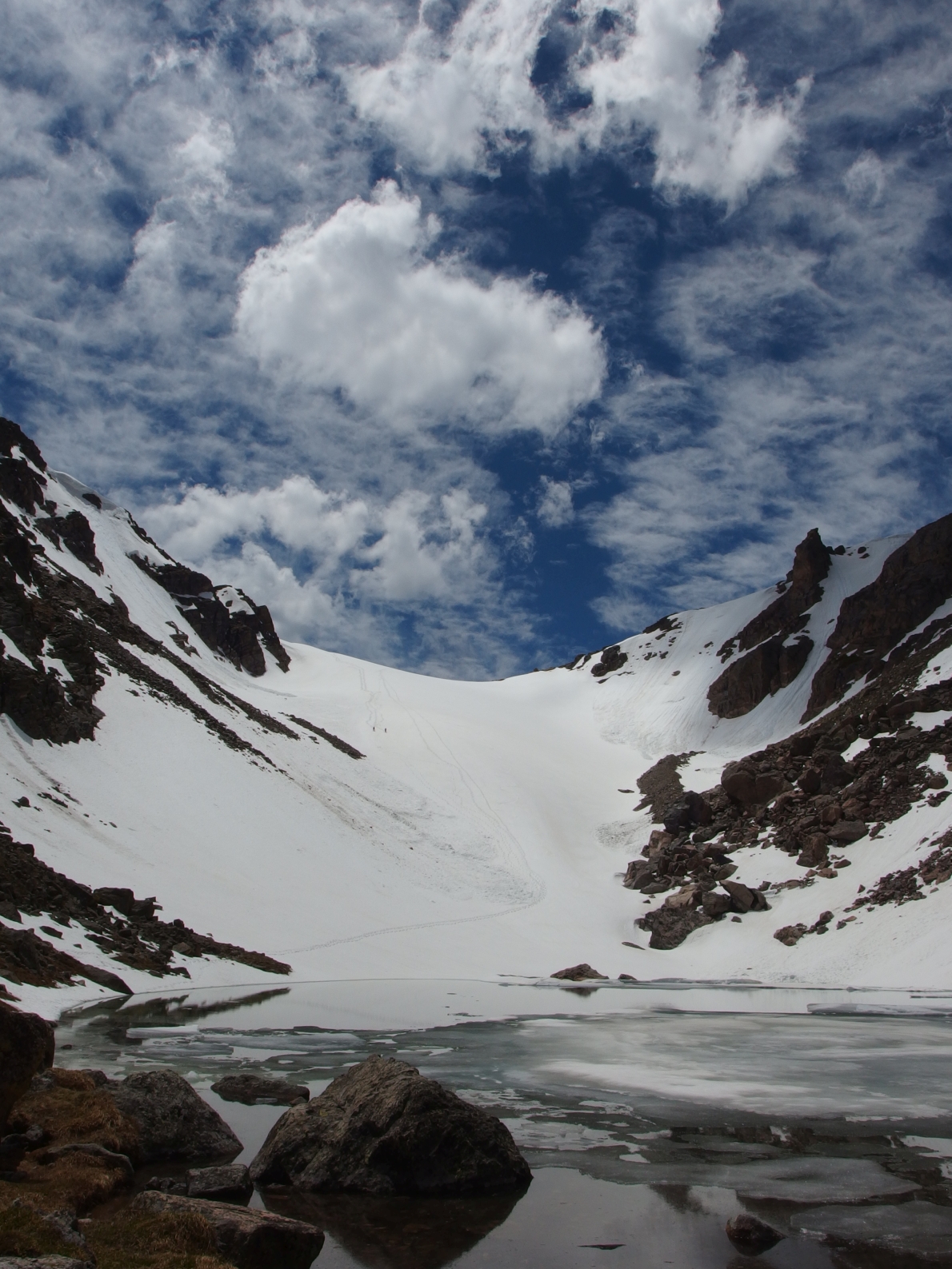
But soon enough I was at Glacier Gorge, and headed up, taking the Fire Trail shortcut.  I made good time to The Loch, where I was greeted by twilight.
Early, early morning.  I love this photo.
From The Loch on, I'd face some snow, and got out the microspikes.  They certainly helped on the steeper slopes around Timberline Falls.
Getting close to the falls.
True sunrise hit right as I got to Sky Pond.  Sometimes I hate getting up early on little sleep, but then I am reminded that it is worth it to get to see the very first light of the day from somewhere special.
First sun on Cathedral Spires.  Like seeing god.
I was able to get the first good views of the goal for the day, lurking at the back of the gorge.  And from this vantage point things didn't look so bad.  It's always hard to tell with snow, as I have seen steep things be flattened out, or look steeper than they are.
I stayed on microspikes as I walked on the apron of the glacier, stuff in the 20 degree range.  But it soon became clear that things were turning up, so I stopped to change into crampons, don a helmet, and get out an ice axe and an ice tool at around 11,500 feet.
Still looked pretty okay.  I'd take the right finish as described in the TR Gary was along on, and I could not see that from here.
Two days before, I'd looked down at this option, but the snow isn't continuous to the top, and the rock looked slightly loose.
I started up the glacier, getting into a rhythm of movement and breathing.  I felt like I was moving pretty well, and my tracker shows that in the first twenty minutes of the climb, I'd taken down about 500 feet.  Not bad. 
I found a small depression to rest in and take some layers off.  I was in direct sun, and the wind I'd encountered earlier on was completely gone for now.  What a beautiful view. 
Looking to the south, you can already see how steep things were at this point.  Looks like slightly more than 45 degrees.
I continued up, and travel slowed remarkably when the snow became firm enough that I couldn't kick steps in.  I had to use the other side of my ice axe to chop in some steps, which of course took alot of time. 
I was now clearly entering the steeper sections of the climb.  I started to get jimmy leg, and made my way right to some rock for a rest.  Since I am more comfortable on rock, I stayed on this for a bit, moving up slowly but surely.
Eventually I reached a place where I could not continue up on rock, and got onto a small snow platform to examine the options.
I had stopped for a snack at the rock band right of center on the way up.  It looked pretty far below now.
I was looking at this to continue up.  I was so close!  But this stretch was super steep, and I could see a near vertical headwall at the top.  I looked at the rock across from me, but it looked too slabby and not featured enough for my tastes.  I felt a down climb would be extremely dangerous.
Looking across from this platform.  Now things looked steep!
I geared up again, and moved out onto the snow carefully and purposefully.  The good news was that it had now softened up enough to allow me to kick steps directly in, and the movement was quicker.  At this point the snow was steep enough that my knee would hit the slope in front of me when I stood up on the step I just kicked in.
I got to the headwall, which was taller than me.  I started right, but then decided to look left.  That didn't look like a viable option, so right it was.  I put the axe in around a corner, and then the tool in over the top.  I pulled in, and got the right heel up to sink the crampon in.  Yes, I found myself mantling at the top of a 1,200 foot tall snow field!  One or two more hand movements, and I was on flat ground.  I was pretty happy to be there.
I inexpertly stitched three photos together to give this complete view from the top on down. 
Another shot of the headwall and the last section of climbing.  You can see the small platform I stopped at near the lower right hand corner.
While I climbed the first 500 feet in 20 minutes, it took me about an hour and forty minutes to cover the remaining 700 feet to the top.  An hour of the was spent on the final 400 feet alone.
This climb was definitely the hardest snow climb I've done to date, and I would say right at the limit for me.  I think having better/nicer boots and crampons would have made a difference, but the only way I will ever climb this again is with a partner and protection.
I cooled off some in the wind on the continental divide.  Powell Peak wasn't too far away, and I decided to go visit it again. 
Near the summit of Powell, with McHenrys center, Longs left, and Chiefs Head right.  I had packed pretty lightly, and needed to keep moving to stay warm with the wind.  This kind of sounds like an amateur mistake, but I know what I am capable of, and how fast I can move, and often trade comfort for less weight and the ability to move quicker.  Which of course, keeps me warm.
I broke one of my hiking poles on Powell.  This peak eats them, as last year I'd broken one of my previous pair on the same peak!
Looking back to Taylor.
From here I didn't know what to do.  I could descend Andrews Glacier again, but it was now getting pretty late (relatively) and I felt like the slope below the tarn is steep enough to slide.  And I was mentally done climbing snow!  That of course, left one option- traverse back to Flattop and take the trail.  Why not.  This would be a good period of exercise above treeline, and still get me home at a reasonable time.
I could see Lake Nanita and Nokoni from here, with Ptarmigan Mountain above.  Some fun times there.
Cathedral Spires from above, with the Mummy Range visible behind, and Sky Pond, Lake of Glass, and The Loch down in the gorge.
Getting close to the summit of Taylor Peak.  The second time I would stand on it in three days.
Taylor Glacier looks steep as insert swear word of your choice here.  You cannot see the exit I took, but you can see some of the stuff I climbed at the bottom middle of the photo.
The more mellow snow slopes of Andrews Glacier and Otis Peak behind.
Otis Peak again.  The long ramp up Taylor behind. 
Since it was all cloudy two days before when I climbed it, here is the top of Chaotic Glacier.  It looks steep for sure, but not as much as Taylor.
Down Chaos Canyon.
This sign probably once said something about danger and steep snow fields.  It has worn in a pretty unique and beautiful way. 
I made it to the top of Hallett, which provided the requisite great views in every direction.  I would certainly suggest Hallett as a great more difficult moderate hike. 
To the north.  The snow has melted significantly in the two weeks since I'd last been there. 
It was slow going down Flattop.  I wasn't motivated to really try, my knees were feeling it, and there was still a fair amount of snow below treeline, though it is melting quickly.  It was pretty wet overall.  I'd like to get back up there this week, but I think I'll wait until the snow is gone completely.  It took me about two hours to descend back to the Glacier Gorge th, which seems average.  I was really looking forward to getting back to the car!
What a day!  While I can certainly look back on some days that have pushed me to the limit mentally or physically, I think this was one that really pushed skills and equipment to the limit.  I was definitely a little freaked out once I got up high and looked around to see how steep everything was.  I did the best thing I could do for me, which was to just think about the options and examine where I was.
I would suggest Taylor Glacier to be one of the most difficult non technical snow climbs in RMNP.  This was definitely a step above Dragonstooth or Chaotic Glacier.  I would suggest AI2, as that grade equates to consistent 60 degree slopes, while AI3 suggests sustained 70 degree slopes, with even steeper sections.  I feel the top few hundred feet are definitely 60+ degrees, and depending on exactly what exit you take, you will likely have a few feet of near vertical climbing, as seen on the photos from higher up.
Of course, there are other thoughts out there, and I have linked to some of those reports.  But most of these TR's seem to indicate what I feel.  This is the real deal, people have died climbing this, and you must be prepared.  Absolutely do not head out to this glacier without a helmet, two ice tools, and good crampons and boots, my weakest link.  I would really suggest bringing and using protection.  But this is one persons opinion, and we all have our own comfort levels.   Decide on yours and climb on!
Taylor Glacier, Powell Peak, Taylor Peak, Otis Peak, Hallett Peak, and Flattop Mountain (distances as part of the hike):
Taylor Glacier, 11500-12700 feet: 4 miles to apron, 3520 foot gain to top.  1,200 feet of climbing on 60+ degree snow, AI2, fourth class.  Strenuous+.*
Powell Peak, 13208 feet: 5.5 miles, 4028 foot gain.  Second class.  Strenuous.
Taylor Peak, 13153 feet: 6.9 miles, 3973 foot gain.  Second class.  Strenuous. 
Otis Peak, 12486 feet: 8.4 miles, 3306 foot gain.  Second class.  Moderate+.
Hallett Peak, 12713 feet: 9.5 miles, 3533 foot gain.  Second class.  Moderate+.
Flattop Mountain, 12324 feet: 10.2 miles, 3144 foot gain.  Second class.  Moderate+.
As a whole, this hike covered approximately 14.8 miles with 5945 feet of elevation gain.  Strenuous. 
*I felt the rock I climbed was fourth class.  If you stay on snow all the way to the top, it'll be second class.  Again I will state that climbing Taylor Glacier requires special equipment and skill.  Do not attempt this climb unless you have both. 

Sunday, July 19, 2015

Five lake loop and Lake Haiyaya Knobs

Occasionally I will check Listsofjohn.com (truly a great reference) to make sure I have gotten to every named peak in a certain area, just to double check.  As I have said a few times in the past, while an incredible reference, Fosters book doesn't include every peak in the park.  There are several ranked but unofficially named peaks that didn't make the cut, and ranked but unnamed peaks were not included either.  
In this case, the 'knobs' around Lake Haiyaha were named in the book "Backcountry Skiing and Ski Mountaineering in Rocky Mountain National Park” by Mark Kelly, which came out in 2013, well after Fosters book was published, thus they are not in her book.
The Knobs near Lake Haiyaha.
Anyway, it was during one of my forays on LOJ that I noticed these high points pop up.  It would be a short day to get them, and certainly violate my unoffical "the total time of the drive each way must be shorter than the time of the activity rule".  When hiking, that is usually no concern!
So I decided to string together a series of lakes in a loop, and run it... well, as much as I could.  Thus I planned to start at Glacier Gorge, take the trail by Alberta Falls to Mills Lake, then hit the Loch, then Lake Haiyaya and the knobs, then Dream Lake, and finally Nymph Lake before taking the trail back down to Glacier Gorge.  Bear or Emerald Lakes could easily be added on for (slightly) more distance.
There were a few other cars in the parking lot when I arrived, but nothing like what was there when I got back.
Half Mountain from the trail.
Mills Lake was beautiful as always.  A quick moment here and I headed back down.
Longs Peak in clouds.  It was only hours before that Andrew Hamilton had finished off the 14ers here, and set a new record of 9 days, 21 hours, and 51 minutes to take almost a full day off the record that had been in place for 15 years!  Well done Andrew and my congrats!
I turned off to The Loch and started up.  Not too long after I was there.
I could see some people working their way around the lake en route to higher altitudes.
The trail from The Loch junction to Lake Haiyaha held some of the steepest terrain of the day, and I simply quickly hiked most of it.  This marks the first time I'd been on this trail in the summer.
Lake Haiyaha is pretty cool.  I think this would stand out in my mind as a nice family destination because it is just hard enough, has great views, and I can imagine kids having a ton of fun exploring the boulders in the area.
After the lake, I got back on the trail headed north and took off east shortly after to find Knob #4.  I didn't take a photo from it, but it was just a short walk over.
From that I headed down to Chaos Canyon Cascades, a series of falls that I had yet to visit. 
This was pretty cool.  Very peaceful to be so close to a very popular trail yet feel completely isolated.  Simply follow a thin trail down the south side of the creek when you cross the outlet.  It's maybe five minutes from the trail.
This small boulder marked the high point of Goblin Knob.  It's a short third class scramble to the top.
The view to points north. 
And a great view to Longs Peak, Thatchtop, and Knob #4 dead center.
Some clearing on Longs.
The Bulge is mere feet from the trail, but again I did not take a photo.  From there I headed uphill west over some rocky and bushwhacky terrain to arrive at Dream Knob.  Due to the off trail travel, this was definitely the most difficult of the high points to find. 
Dream Knob and twisted pines.
I went back down to the trail and then made a similar approach to Knob #1, again not pictured, and again just a short jaunt off the trail.
I got back on the trail and headed down.  It was a different experience.  I am usually used to seeing no one at all, but passed a ton of people as I headed down.  I arrived to a full parking lot about three hours after I'd left.
This was a fun shorter day.  Chaos Canyon Cascades is certainly worth the short side trip down from the trail, and is more impressive than some of the named waterfalls in the park.  Of the knobs, I'd suggest Goblin Knob and Knob #4 as being the best as both are relatively easy to get to, and both offer some pretty darn good views.
Five Lake Loop and the Knobs:
Mills Lake, 9940 feet: 2.7 miles one way, 760 foot gain.  Moderate.
The Loch, 10180 feet: 2.9 miles one way, 1000 foot gain.  Moderate.
Lake Haiyaha, 10220 feet: 3.3 miles one way, 1040 foot gain.  Moderate.*
Chaos Canyon Cascades, 9840 feet: 3ish miles one way, 660 foot gain.  Moderate.*
Knob #4, 10180 feet: 3ish miles one way, 1000 foot gain.  Moderate.*
Goblin Knob, 10220 feet: 3ish miles one way, 1040 foot gain.  Moderate.*
The Bulge, 10190 feet: 3.2ish miles one way, 1010 foot gain.  Moderate.*
Dream Knob, 10460 feet: 3.3ish miles one way, 1280 foot gain.  Moderate.*
Knob #1, 10260 feet: 3.3ish miles one way, 1080 foot gain.  Moderate.*
Dream Lake, 9900 feet: 1.1 miles one way, 450 foot gain.  Easy+.
Nymph Lake, 9700 feet: .6 miles one way, 250 foot gain.  Easy.
* = From Glacier Gorge TH, subtract about a mile if starting from Bear Lake TH.
As a whole, this hike covered approximately 8 miles with 2000 feet of elevation gain.  Moderate.

Wednesday, June 10, 2015

Powell Peak via Andrews Glacier.

I have had some great days outdoors this week.  Monday I got up to some higher altitudes for some fun mountain biking.  I found myself ripping downhill on ten inch wide single track through a meadow of wildflowers and wondered if life could get any better.  Well, I had to head to work after that, so no!  But it is those moments of perfection that I seek, where everything comes together even if only for a second.
I didn't sleep much that night since I had to close.  Bleary eyed to answer the 4:15 alarm, I slathered on sunscreen, put in my contacts, made some food, and started the drive up to Estes Park.  A few thoughts for the day had run through my head.  There are a few snow climbs I would like to accomplish this year.  But the look at the mountains from my highpoint on Monday told me it might still be too early for these.  So what to do?  
I started from the Glacier Gorge trail head at 6:15.  I took the Fire Trail both ways.  Alberta Falls is nice and all, but I've now seen it multiple times in every season.  
Working up to The Loch.  In the winter, you can just stay down in the valley.
The Loch was quite pretty, just as always.  I happened to make it up early enough on a low wind day and got a few nice reflective photos.  Directly ahead you can see the flat face of the peninsula of land that juts out from the Continental Divide and holds The Sharkstooth amongst other features.  To the left, find Sky Pond, and to the right you can see the top of Andrews Glacier.
Since I'd never been up here before, I somehow ended up staying on the mashed into the snow trail a little bit longer than I should.  The crampons were put on and I faced what would be the steepest snow climb of the day as I made my way uphill and into the basin holding Andrews Creek.
You can see some footprints here, and I could see footprints in places for most of the day.  Simply head up to reach Andrews Tarn.  I was feeling a little bit better heading up than I was last week.  Hopefully some of that fitness is coming back to me.  
I found the snow slope lying below Andrews Tarn to be steeper than the glacier itself, maybe 30+ degrees.  I stopped to take a picture of The Sharkstooth.  It looks pretty awesome sticking up by itself there.  Note the sliver of moon in the upper right corner.
I stopped at the tarn and had a snack.  There had been a little bit of slide activity on both sides of the glacier and I could see the footprints went around it.  Like always, it looked steeper and more imposing than it really was.  I felt I could have gone up in microspikes, but of course, better to be safe than sorry!
Contrary to earlier, I felt like I was dragging up the glacier.  The late turn cost me some time and energy.  All I could do was go at my pace.  In the end, I topped out the glacier about three hours and fifteen minutes after I left the car.
Taylor Peak loomed large.  All I could do was think about the last time I was here and how bad I felt then.  I started up, keeping the crampons on for the time being.  
Looking back at how much snow there is.  Fortunately, it is melting and consolidating, and largely held my body weight.  Postholing could have turned this day into a real slog.  The weather was great, with a nice cool wind blowing to offset my uphill energy.  I wore a tshirt the entire day.
I felt alot better ascending Taylor.  It is a little less than a mile from Andrews Pass and around 1200 feet of gain.  It offers some great views of Longs Peak.
Powell Peak still looked very far away.  I couldn't remember how far, or how much loss and gain would be needed to get there.  If I stayed close to the edge of the divide, I could stay on snow most of the way and minimize the elevation loss.  I started descending on talus and took off my crampons soon enough.  The traction simply was not needed on the snow and they were more of a hassle than an asset on the rock.
Taylor Glacier, Glass Lake.
I felt as though I was moving well, though again I was not going very quickly.  But I could finally see the summit of Powell Peak, with McHenrys and Longs in the background.  At some point during the hike, I realized that this could be my last ranked 13er in the park.  I ran through a mental list and found that it was indeed, with a few unranked points above 13k left to go, such as SE Longs and Glacier Ridge.
From what I could see from the summit, McHenrys Notch looked difficult but reasonable.  Once out of the notch, it looks like some easier terrain awaits to the summit, before entering some third class on the descent on the other side.  
Snow everywhere.  The Rabbit Hole Couloir of Mount Alice had been a thought for this week.  Maybe in another week or two, as there is still alot of snow up there.
I had a snack on the summit and planned to lounge around for a little bit.  That turned into a get packed and get going quickly when I heard thunder.  None of the clouds I could see looked threatening, but better to be on the safe side and head back.
I stopped at Andrews Pass for a snack and to trade the hiking poles for an ice axe.  I thought I heard voices, and looked up to Otis Peak, where I saw two people descending toward the pass.  We met up and talked.  It is always nice to run into people out there in what is essentially the middle of nowhere.  We shared some stories and took a few photos and were then on our way.  The descent was quick- I ran down and attempted to slide once, but the top layer of snow was so soft I could not get going.  Back at the tarn I looked up...
I thought these photos would turn out well, but this might be the single best series I have ever taken in the mountains.  Click to zoom in and find the two black dots on the upper left side of the glacier.  These are the two people I met descending.  
Seen here in close up.  
A pretty wonderful place to be!
I was able to glissade the slope below the tarn, and felt like I created a minor slide of my own as the top layer of snow was pretty slushy.  I stayed down in the basin and followed the footsteps down to get back to the trail in the right place.  As it turned out, the turn off wasn't obvious, but I still feel I shouldn't have missed it.  Ah well.
Back at The Loch I had a snack and reveled in another windless photo opportunity.  I started to see some people around The Loch, and passed a few on my way back down.  On the Fire Trail yet again, I enjoyed the quiet and solitude of the forest and thought about life for awhile.  Back on the official trail, I saw a few more people but avoided my favorite question- "How far?"
The trailside philosopher in me always wants to reply to that question by asking, "Does it matter?", but I usually give some time or distance guess, or the vague, "You're getting there", or something of that sort.
I got back to the car at precisely 3:36, giving me nine hours and twenty one minutes to do this hike.  I loved every second of it.  Despite only sleeping four and a half hours the night before, I felt rather chipper.  'If only I had my running shoes,' I thought.  'And more water.'  'And a big plate of food.'
The drive back home was uneventful and punctuated with a trip to the grocery store.  Not five hours before I had been lounging in sunshine at 13208 feet.  Life was perfect for a few hours.
All in, this is not a very technically difficult hike.  Andrews Glacier is pretty mellow in grade, though it should be noted it can still form crevasses, and as it terminates into frigid water, a uncontrolled slide down could result in a potentially life threatening situation.  Thus I would recommend the usage of an ice axe or hiking poles as an aid to control the speed of your descent.  Taylor and Powell are no more than second class on grass and scree in the summer months, or some combination of those and snow in winter.
Powell Peak is named for John Wesley Powell, an early explorer of the west.
Link to hike map on Caltopo.
Powell Peak via Andrews Glacier (all distances measured using the Fire Trail, add about a mile if not):
The Loch, 10190 feet: 1.7 miles each way, 1040 foot elevation gain.  Moderate.
Andrews Tarn, 11390 feet: 3.3 miles each way, 2150 foot gain.  Moderate+.
Andrews Glacier, 11650 feet (approximately the middle): 3.6 miles one way, 2410 foot gain.  Moderate+
Andrews Pass, 11980 feet: 3.8 miles one way, 2740 foot gain.  Moderate+.
Taylor Peak, 13153 feet: 4.7 miles one way, 3913 foot gain.  Strenuous-.
Powell Peak, 13208 feet: 6.1 miles one way, 3968 foot gain.  Strenuous-.
As a whole, this hike covered approximately 12 miles with 4800 feet of gross elevation gain.  Strenuous.