Wednesday, November 7, 2012

Chiefs Head Peak via Sandbeach Lake.

Just a week before Dan and I hiked to the high lakes of Glacier Gorge.  Earlier in the year we had talked about doing Chiefs Head Peak, but wanted to wait until later in the year since it seemed doable in winter conditions without worry of avalanche.  The hike and views we got were incredible, and since it did snow the day after, we decided Chiefs Head was a go!
We met up in Lyons and made the drive up relatively quickly.  We started out just as the sun was coming up from the Sandbeach Lake Trail Head.  I of course forgot to bring my headlamp, but no worries.  Our eyes adjusted to the darkness quickly and the growing light of the day helped alot.
St. Vrain drainage from the trail.
There was just a few spotty places of snow until summiting the moraine, typical of my experience with this trail in cooler months.  After that it was packed snow/ice.  Dan put on microspikes.  I only brought full on crampons and didn't feel those were needed, but something would have been nice. 
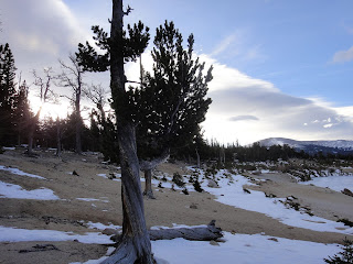
Snow, snow, snow.  I'd say the vast majority of the trees are of the evergreen variety, yet the forest still looks alot more barren and desolate in the winter.
Hunters Creek.  Follow up to get to Dragons Egg Rock and other fun points such as Keplinger Lake.
Looking down Hunters Creek.  Iced over.

Sandbeach Lake is 4.2 miles in and a great hike to do anytime of year.  Since it popular, I would say at most in the winter you'd need traction devices of some sort.  Of course, if fresh snow has fallen, snowshoes would be appropriate.  Copeland Mountain in the background.
Krumholtz on the shores, cool looking clouds.
From Sandbeach Lake, turn right and head up the slope.  There is an unofficial trail which is alot easier to find in the summer, but Mount Orton is the next point of interest you'll come to, and it is relatively easy to get to it.  I would suggest staying more to the north than you think. 
Mount Meeker as seen from somewhere on Mount Ortons slopes.  Around the place where this picture was taken, we found some cairns and followed them up.  I would suggest ascending the rocky slope, and then heading around to the north.  This can largely keep you out of the trees and help you to avoid some unnecessary bushwhacking.
Pagoda Mountain, Longs Peak, and Mount Meeker seen from the ascent of Mount Orton.
Points north in Wild Basin. 
East to the plains.
Dan hadn't gotten to Mount Orton, which is less of a mountain and more of a high point on the ridge.
Looking up North Ridge to Chiefs Head.  The tundra is great hiking here- exceptionally smooth and easy going.
Giants of RMNP- Pagoda is seventh highest in the park, Longs first as well as the northern most 14er in Colorado, Meeker is the second.  Our goal for the day is the third highest peak in RMNP.
Longs Peak from the south.  The lake at the base (which truly lies almost directly south of Pagoda Mountain) is Keplinger Lake.  I would say this stands in my mind as one of the most secluded and beautiful lakes in the park.  A very worthy destination, but all approaches require at least 2.5+ miles of off trail hiking and bushwhacking.
Looking back at Mt. Orton (11724 ft.) from North Ridge. 
Snow sculpted by wind, the high peaks of Wild Basin just poking up.
Getting closer...
I don't think I have seen Ptarmigan in their winter colors as of yet.  If it were a bit snowier, we might not have seen them at all.

The bowl formed by Tanima Peak and Mount Alice.
Here comes the pain.  After a mile or more of relatively flat tundra the next mile gains around 1700 feet.  However, there is nothing more than second class ahead.
Nearing the top, looking down to Glacier Gorge.  Green Lake in the foreground with Blue Lake and Mills Lake seen farther back.  Hard to believe it was only a week ago that we were down there.
And again.
Looking east to Pagoda Mountain, Keyboard of the Winds, Longs Peak, and Mount Meeker.
A little closer up.
South to Wild Basin and beyond.
Some of the high peaks of Wild Basin.
A dizzying look down at the Spearhead and Green Lake.
Looking north into Glacier Gorge and Mummy Range.
A closer look at Jewel and Mills Lakes, both now showing ice.
And away..
On the summit, 13579 feet.
There is a rock near the summit that you can sit on and hang your feet down over lots of air.  Frozen Lake now living up to its name.
Glacier Gorge.
Points east from the true summit.
Clouds forever.
The summit register had been wetted and was frozen.  It will remain untouched by us for the time being.
The wind blown snow was making these awesome looking formations on rocks at the summit.  Reminds me of the little kid experiment of sitting Dolomite in vinegar and watching crystals grow from it...


Dan on the summit.
It was a bit windy, with blobs of snow being blow up at us from Glacier Gorge.  We decided to start to descend and try to find a place with a wind block to have a snack.
Mount Alice, at 13310 feet, is one of the most memorable peaks I have climbed in Wild Basin.
North Ridge on the way back.
Lion Lake #1.
Lion Lake #2 and Snowbank Lake.
On the way back we skirted to the north of Mt. Orton and kept in meadows and grass as we descended past tree line.
A panorama.
L to R- Chiefs Head Peak, 13579 feet, 3rd highest in the park.  Pagoda Mountain 13497 feet, 7th highest.  Longs Peak 14255 feet, highest.  Mount Meeker 13911 feet, 2nd highest.
Back at Sandbeach Lake.  We took a break to eat and shed some clothes as the day was now quite warm.  This also marks the spot where we saw the first and only other group we would see this day. 
Another fun day in the park come to an end..  Well, there's still the 4.2 miles back to the parking lot.
By now the trail had melted out pretty well, making the journey back quite slushy and wet.  We got back to the car just a few minutes after five, giving us a ten hour day.  Not bad.
Chiefs Head Peak was a ton of fun!  This is something that had been on my list, and I was disappointed to not be able to get to it earlier, but happy to have crossed it off now.  Dan said Chiefs Head is also the highest gain hike in the park when done by its standard route.  Certainly a fun and worthy destination to check out this winter or next summer.
Chiefs Head Peak via Sandbeach Lake:
Chiefs Head Peak, 13579 feet: 7.9 miles one way, 5239 foot gain..  Second class.  Strenuous.
Other fun destinations along the way:
Sandbeach Lake, 10283 feet :  4.2 miles one way, 1943 foot gain.  Moderate-.
Mount Orton, 11724 feet: 5.7 miles one way, 3384 foot gain. Moderate+.

The high lakes of Glacier Gorge.

Last week we set out aimed at some of the higher lakes of Glacier Gorge.  This is a sector of RMNP that I have not hiked in much if at all, and a fun change from Wild Basin.
The drive up was mellow, and it was pleasant to start a bit later.  We did briefly get stuck in the Bear Lake Road construction, but were soon able to follow a spotter vehicle up the road.
We started off from the trailhead a little after 730am on October 24.  Our ultimate goal for the day was Black Lake, but we decided if we felt good, my leg felt good, and the weather held (this was the day during/before our first winter storm of the year), we might hit some of the others.   
Early morning on the Glacier Gorge trail.

Soon we reached Alberta Falls.  As Lisa Foster says, "This is a good hike for children and anyone desiring a short, rewarding hike in RMNP."  And I have hiked here before with my parents from Bear Lake on the advice of a park ranger. 

Albert Falls.
Low clouds in the early morning and throughout the day made from some impressive looking photos.
Peaks in the mist.
Somewhere, sometime.
We passed through an area that must've seen a high wind event at some point in the past year.  As always, it was amazing to see these huge trees snapped like toothpicks and torn out of the ground like blades of grass.
 At 5.4 miles round trip, Mills Lake is a destination I'd definitely consider visiting if you haven't already. 

Just look at it!  That is one sexy lake!
Looking up the Gorge to oblivion.
Our destination was farther on, higher up.  Into the clouds we headed.   
Chiefs Head/Pagoda couloir.
Next up was Black Lake.  This is a pretty cool sub-alpine lake (10620 ft.) and at 4.9 miles each way, entirely reasonable for a higher elevation but shorter hike in RMNP.
Arrowhead as seen from Black Lake.
More Black Lake.
Arrowhead (12640+ ft) will be on the list for next year.
From here, the trail winds around the lake and travels up, up, and away.  These granite benches will be on your right.  During warmer months, I bet these cascades are quite pretty.  During colder months they are pretty as well, but in a different way.
A cleared view of Arrowhead and McHenrys Peak as we rise above Black Lake.
Once we gained the drainage above Black Lake the trail became harder to see, and not as well marked.  There was a bit of snow which didn't help.  And a wealth of cairns, many of which appeared to lead to nowhere.  It may very well be easier to find your way in the summer months, but outside of that, it is still easy to find your way.
The Spearhead is the large triangular shaped tower in front of Chiefs Head.  Simply find your way to its right to get to Frozen Lake, or to the left to get to Green Lake.

A later goal of Blue Lake seen from near Frozen Lake.
At Frozen Lake (11580 ft), which as you can see, was not yet Frozen. 
A small yet scenic bowl.
Mummy Range beyond.

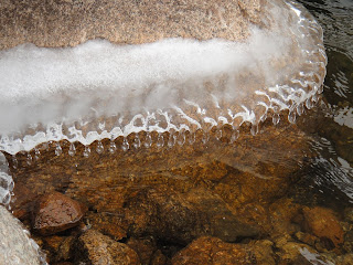
Some delicate ice starting to form around the edges of the lake.
Up from Frozen Lake to Chiefs Head Peak.
From Frozen Lake we decided to make our way around The Spearhead and drop down to Green Lake.  Actually we thought we wouldn't have to drop down, and stayed fairly high around the bottom of the cliff face, only to discover a descent awaiting us on the other side.
The Spearhead certainly looks as though it could hold some fun climbing routes.  Not sure if anything is established there as of yet.
Keyboard of the Winds, Pagoda Mountain, Chiefs Head/Pagoda couloir as seen from above Green Lake.
Dan dropping down to Green Lake (11540 ft).  Longs Peak in the background.
The Spearhead as seen from Green Lake.
I was just awe struck with the supreme alpine beauty of this bowl.  It is a must hike in my opinion.  Here are a bunch of pictures.
Keyboard of the winds.
Pagoda Mountain.
Chiefs Head Peak.
The Spearhead.

More The Spearhead.
Looking almost due east.
The moraine to the immediate south.
Back up to Longs and Keyboard of the Winds.
Pagoda looming over Green Lake.  This is the only peak surrounding Wild Basin that I have not climbed.
Looking back at Green Lake as we move on.
A panorama shot from Green Lake showing the peaks surrounding the bowl.
We did this hike on October 24, which was the night we got our first snow of the season.  The lower clouds rolling in here made for some awesome photos and light snow.
Mummy Range and points lower now in clouds.
We decided rather than go down and attempt to find a trail, we would try to head directly towards Blue Lake and maintain a constant elevation.  This worked pretty well.
Ice forming over rock on the north side of Longs Peak.
Dan approaching Blue Lake.
Blue Lake (11,140 ft).
Clouds we starting to blow up into the Gorge before reaching a certain elevation and swirling up into nothingness.  It was very pretty.
Dan in front of Arrowhead.
Making our way down to the lake, where we found all the ice that has formed so far blown to the east side of the lake.
Blue Lake with Chiefs Head Peak in the background.
McHenrys and Arrowhead as seen from Blue Lake.
Keyboard of the Winds, Pagoda Mountain.
Yours truly.
We stopped to eat lunch behind a wind block slightly north of the lake.  The swirling clouds continued to amaze and delight us, making each moment a photograph.


The sun struggling to poke out.
Unforgettable views.

Eventually, we got up and continued on our way.  We worked back in a north westerly direction, bypassing some steep but short drop offs, and the drainage from Blue Lake.  We found the trail back to Black Lake and on we went.

McHenrys Peak.
Can't get enough of the clouds!
Looking back up from farther down.
Descending to Black Lake.
Almost there, slightly reflective.
Of course, from here on out the hiking was rather easy and all downhill.  We took the Fire Trail back to the trail head, which cuts a little distance off the hike. 
Stopped at Mills Lake in the afternoon.  The low clouds have now completely obscured the view up.
This was a rather fun hike!  Great views abound, and though you do go above treeline, you start higher when compared to Wild Basin.  Movement at elevation is no less difficult, but it takes less time to get there.
The views from the bowl around Green Lake are spectacular, and this would put it high on my list of best places to be in RMNP.
The high lakes of Glacier Gorge:
Mills Lake (9940 ft): 2.7 miles one way, 760 foot gain.  Moderate.
Black Lake (10620 ft): 4.9 miles one way, 1440 foot gain.  Moderate+.
Frozen Lake (11580 ft): 6.1 miles one way, 2400 foot gain.  Strenuous-.
Green Lake (11540 ft): 6 miles one way, 2360 foot gain.  Strenuous-.
Blue Lake (11140 ft): 5.5 miles one way, 1960 foot gain.  Strenuous-.