Tuesday, January 29, 2013

Storm Peak and Battle Mountain.

Of course I mentioned last time around how I wanted to add on Storm Peak.  With once again nice weather this past week, I had the opportunity to go for it.
The temperature was fifteen degrees higher when I arrived at the Longs Peak TH at seven am on January 23.  I shed some clothing before even starting and made my way up the packed snow with Yaktrax only.
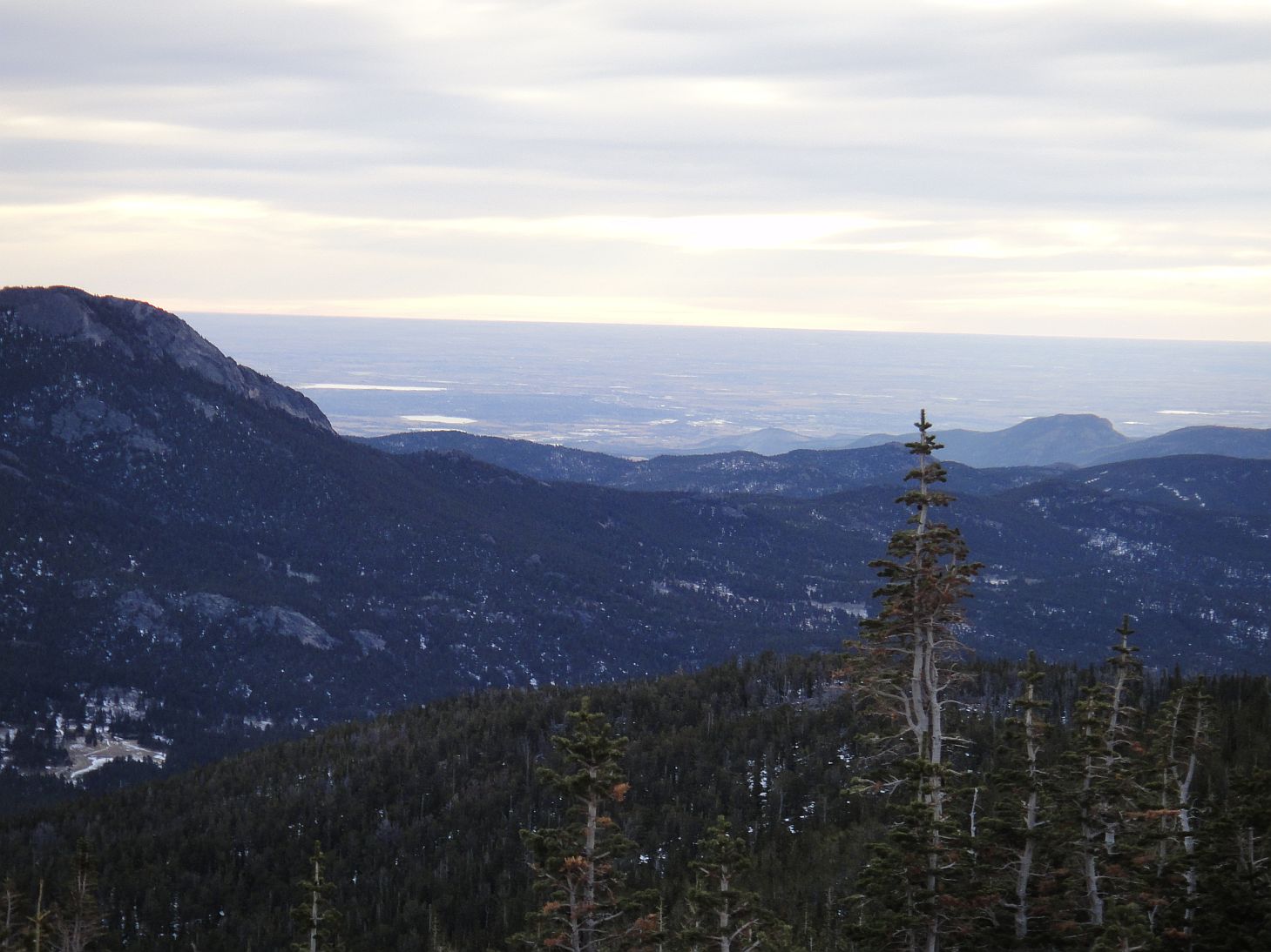
The views on the way up are exactly the same as for Mt. Lady Washington, so I skipped taking some similar photos this time.
But, hard to resist the views of Longs. 
Twin Sisters and plains behind. 
A pretty cool view of Meeker, Ships Prow, Longs, and Mt. Lady Washington from the Chasm Lake trail split.
The north ridge of Mt. Lady Washington.  Really it looks like just a bump in this picture.
As I escaped tree line, the wind was more of a factor.  It was steady and less gusty, but I felt I would be ok to do Storm Peak since the wind was from the west and the mountain itself would block the majority of it.
The Boulderfield and Longs Peak.
It seems many do not take this sign that seriously.  A friend told me of being on top of Longs and finding someone who had not brought any water at all. 
Storm Peak as seen from the Boulderfield camping area.  I basically tried to move around the areas of the most snow.  Crampons were still a must. 
I didn't realize how steep the snow was until I snapped this photo.  Definitely in do not fall territory here. 
Storm Peak seemed easier to ascend than Mt. Lady Washington, probably because you start off at the base of it significantly higher.  I made it to the top and got this view of Chiefs Head Peak and Glacier Gorge
McHenrys Peak is one of the most technically difficult 13ers in the park.
Longs as seen from Storm Peak.
Lady Washington as seen from Storm Peak.
Me as seen from Storm Peak.
I must say, I really had a difficult time finding the true high point of this peak.  From the southern most point, there was one in the middle and one to the north that looked higher.  From those, the southern most point looked higher.  I was unable to find a summit register or notice any cairns. 
Looking north to ideas yet realized.
Chiefs Head Peak and The Spearhead.
The descent was relatively straightforward.  On the way down, I tried to stay in snow and avoid rock.  I could feel the snow had softened since I went up.
At the bottom looking back up.
It was still relatively early in the day, and I decided that while I was here, I would walk over to Battle Mountain as well.  I followed the East Longs Peak trail back to Granite Pass, and then hooked a left on the North Longs Peak trail to approach the summit.  As the trail looked to loose a good amount of elevation that I'd have to regain and the tundra looked relatively flat, I set off across it shortly after, heading directly for the high point, which is on the third hump heading north east.
I didn't face much snow or anything at all really, and shortly after arrived at the base of the summit block.  Of note: there must be a family of Pica or Marmot that live here, because there was more crap than I have ever seen in one place. 
It is a short scramble to ascend to the summit, which offers views such as this, looking back to the Keyhole.
Or this, Meeker, Lady Washington, Longs, and Storm.
Back east.
Now being fully exposed to the wind, I opted to protect my skin a bit more.
The little point sticking up from this pile of rock is the summit. 
Granite Pass and the worlds largest cairn.
To get back to the trail I stayed on the south side of Battle Mountain and wove my way through, around, and over some talus.  This was just slightly more difficult than the approach from the north. 
Looking back at Battle Mountain from the trail.  Again what is the true high point does not look to be. 
Peacock Pool, Columbine Falls, Ships Prow, and the Loft in the afternoon. 
Battle Mountain as seen from the descent.
This time I did not loose the trail on the way back down and managed to run/walk/slide the packed snow trail back to the parking lot in a relatively reasonable time.  If only I had a sled!
This was a pretty fun hike overall.  Storm Peak could be a fun add on to Longs if one planned to leave early enough.  Battle Mountain is probably often bypassed, but it does not take long to get to and back if you're up there already, and is one of those cool high points that are off the beaten path and probably not visited all that much, at least compared to Longs.
I am not hiking this week due to a very windy weather forecast.  I wish I was though.
Storm Peak and Battle Mountain via Longs Peak TH:
Storm Peak:
6.3 miles one way, 3926 foot gain.  Second class when dry, steep snow in winter.  Strenuous-.
Battle Mountain:
4.8 miles one way, 2644 foot gain.  Second class.  Moderate+.

Sunday, January 20, 2013

Mt. Lady Washington in the winter.

Well, I have finally found my own transportation besides a motorcycle, which means I should be able to get out alot more in the next year.  This week I did something on my list as a bit of a winter warm up.  It seemed appropriate since we are in a winter warm up of our own here, with temperatures predicted to top out at 65 degrees this week.
Mt. Lady Washington is in the Longs Peak group, and was on my radar for something to do in the winter since I knew it would not be technical and there is little to no risk of avalanche.
I arrived at the Longs Peak TH shortly after seven am, the only vehicle in the parking lot.  It was warmer than I expected, and it took me a little bit of time to get situated as far as clothing and traction devices in the first mile or so. 
Twin Sisters as seen from the trail.
The trail is in great shape, completely packed at this point and well delineated.
Reaching tree line, and a sign that I have never seen before.
Twin Sisters proved to be easy to see and very photogenic throughout the day. 
Tree line being passed, and my goal seen along with Mt. Meeker and Longs Peak.
I was able to follow the trail for the most part, though things got a bit difficult to see here and there with the blown snow.  But since I was able to see where I was going quite well, there were no troubles. 
I eventually broke from the trail and started up the east ridge of the mountain.
Increasingly good views of Longs.
Points north east.
It took me quite a while to scramble up the ridge.  Of course with snow and ice, it is important to take your time!
Ships Prow looming!  A pretty cool view!
Finally arriving at the summit.  The view of Longs as you crest the peak is simply amazing!  The Diamond is one of Colorados most iconic images, and you get an up close view.
Mount Meeker.
Second highest and highest peaks in the park!

Very back lit, but on the top and loving it!

Storm Peak and some others for the future.
Mummy Range.
At this point, I was thinking about adding on Storm Peak.  It didn't look too far away.  But when I took a look at the clock, I knew it would have to wait for another day. 
Back east with Twin Sisters now looking tiny.
The Diamond.
A panorama which does not do the view justice.
Chasm Lake frozen well below.
I decided to descend the western slope, just for comparisons sake.  I found it to be a bit snowier and therefore slipperier.  I noticed the keyhole, part of the most popular route to climb Longs.  Note the Agnes Vaille hut just to the left of the keyhole.
Not zoomed in.  The boulderfield was a little deceptively named.  More like small pieces of talus field.  That has a certain ring to it!
Storm Peak from the boulderfield.
Looking up the west slope of Mt. Lady Washington.
The low clouds...
...played with these peaks all day.

Sunshine highlights the ridge I had hiked up just hours before.
Twin Sisters.
A neat windblown snow sculpture.  The compressed snow under someones feet has stayed in place, with the loose snow blowing away.
About this time I was cursing my decision to bring snow shoes.  I had not used them at all, and had drug the extra weight all the way up there with me.  My opportunity was soon to come as I lost the trail going back below tree line, and followed someone elses footprints for a bit before becoming immersed in deep powder.  I strapped them on and wandered for a bit, eventually stopping to look closely at a map.
I decided where I most likely was, where the trail should be, and made my way.  It was about 200 feet away from me.
From here it was just a motor back down to the trail head.  I did see one other person on their way down as well, but that was it for the day.
All in all, this is an awesome hike to do any time of the year.  Traffic will probably keep the snow fairly well compacted, so I doubt you'd need snow shoes unless it just snowed the night before.  The view when you arrive at the top is awesome- Longs looms huge and you can get a very good idea of just exactly how big it is.
Mt. Lady Washington in the Winter:
4.2 miles via east ridge, 6.3 via west ridge, 3881 foot gain.  Second class.  Strenuous-.