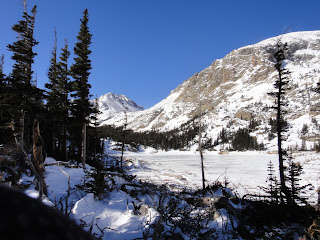
We were atop within forty minutes or so, and were greeted by a great view of the Central peaks - Flattop, Hallett, Otis and more all visible.
The clouds to the east of us prevented sun from hitting any of the peaks this early.
Thunder and Lightning Peaks as seen from Emerald Mountain.
From here, we went back the way we'd come, and caught the Wind River Trail for a brief time before turning off, crossing the frozen river, and starting the bushwhack uphill to Thunder Peak. As far as bushwhacking goes, the ascent isn't too bad- most of it is through relatively open forest, with a little talus here and there. But you do gain about 900 feet per mile, putting this in the pretty steep category.
There are a few false summits, but the true high point comes soon enough, and offers great views.
Longs just starting to stick its head out.
South to Lightning Peak and Longs Area.
Panorama from Thunder Peak.
A loss and regain of several hundred feet between the peaks is of course, something you can't avoid. We simply chose a way down that looked less rocky and easier to hike. We quickly arrived at the saddle between the two peaks, and after a change of clothing for me, started up the snow covered hillside of Lightning Peak.
The snow did complicate travel upward somewhat, adding in some slipping and sliding, but not enough that we used traction devices. We arrived on the summit ridge somewhat northwest of the high point, and had to make our way over. There was some second and third class along the way, but this could be avoided with a different route selection.
This little peak truly is a gem, offering a great and unique view of a good portion of the park.
Longs Peak and area.
Otis, Hallett, Flattop.
Battle Mountain and Longs.
Estes Cone seen from Lighting Peak.
Awesome views!
Twin Sisters Peaks.
The way down was pretty fun hiking/sliding in the snow, through sometimes unique forest as pictured above, with thin but closely spaced trees. Eventually we were able to pick up our footprints up and follow those down.
We made it back to the car in about seven hours, which does mean that our average speed was pretty low. But of course factor in the off trail time (which is most of the hike), and lots of elevation gain and loss and there you go. Lightning Peak was the highlight for me- a fair amount of difficulty in ascent rewarded with great views from the top. Dan was even bold enough to proclaim it his new favorite 10er. That's enough to make me want to get back!
Emerald Mountain, Thunder Peak, Lightning Peak from East Portal TH (all distances measured from TH):
Emerald Mountain: .8 miles one way, 977 foot gain. Moderate.
Thunder Peak: 2 miles one way, 1874 foot gain. Moderate+.
Lightning Peak: 2.3 miles one wat, 2307 foot gain. Moderate+/Strenuous-.


