Showing posts with label andrews glacier. Show all posts

Friday, June 17, 2016

Chaotic Glacier, Otis Peak, and Taylor Peak.

I am in the middle of a week or so off between jobs, and have been enjoying some time in the mountains.  It seems as though I have inadvertently left some of the most difficult destinations in the park for last. With a fair amount of snow hanging around, I thought I'd use this time to tackle two snow climbs I have yet to do.  Unfortunately, these are both toward the steeper and harder side, and with sunrise about as early as it can possibly be, this meant a very early wake up to ensure firm snow from bottom to top.
There were some thunderstorms at the beginning of the week, but good weather predicted for the rest.  Monday night I got to bed late with my alarm set for two am.  I hadn't been able to find much on Chaotic Glacier, the snow and ice headwall that lies at the end of Chaos Canyon, home to Lake HaiyahaThis page talks about Chaos Couloir, which directly ascends Hallett Peak, but also mentions Chaotic Glacier as 60 degrees AI2.  This page talkes about skiing down it.  And this page does actually talk about climbing it, though she says 35-40 degrees and mentions it only took 15 minutes!  Foster says 50-60 degrees, AI2.  Rossiter says steep snow, AI2.  That's about all that's out there on the internet and in books that I own.
Because I could find lots of ratings but only one account of someone actually climbing it, I wasn't quite sure what to expect.  There is a big difference between 35 and 60 degrees of course, but from the photos I could find, it looked closer to the latter.  Consider 35 degrees is around what you'd find on Ptarmigan Glacier, or on the easier sections of Tyndall Glacier.  It definitely looks steeper, though it's always hard to tell.
I left the car at Bear Lake shortly before four and set off.  I didn't sleep well the night before, I think due to nervousness about the day ahead.  But I felt pretty okay. 
Presunrise from the trail.  There was still some snow here and there, most notably after passing the turnoff for Dream and Emerald Lakes.
I lost the official trail as I neared Lake Haiyaha, but all I had to do was go around the lake and head up, so it was pretty easy.  Easy in the talus hopping scramble sense.  
Above Lake Haiyaha as a new day starts.
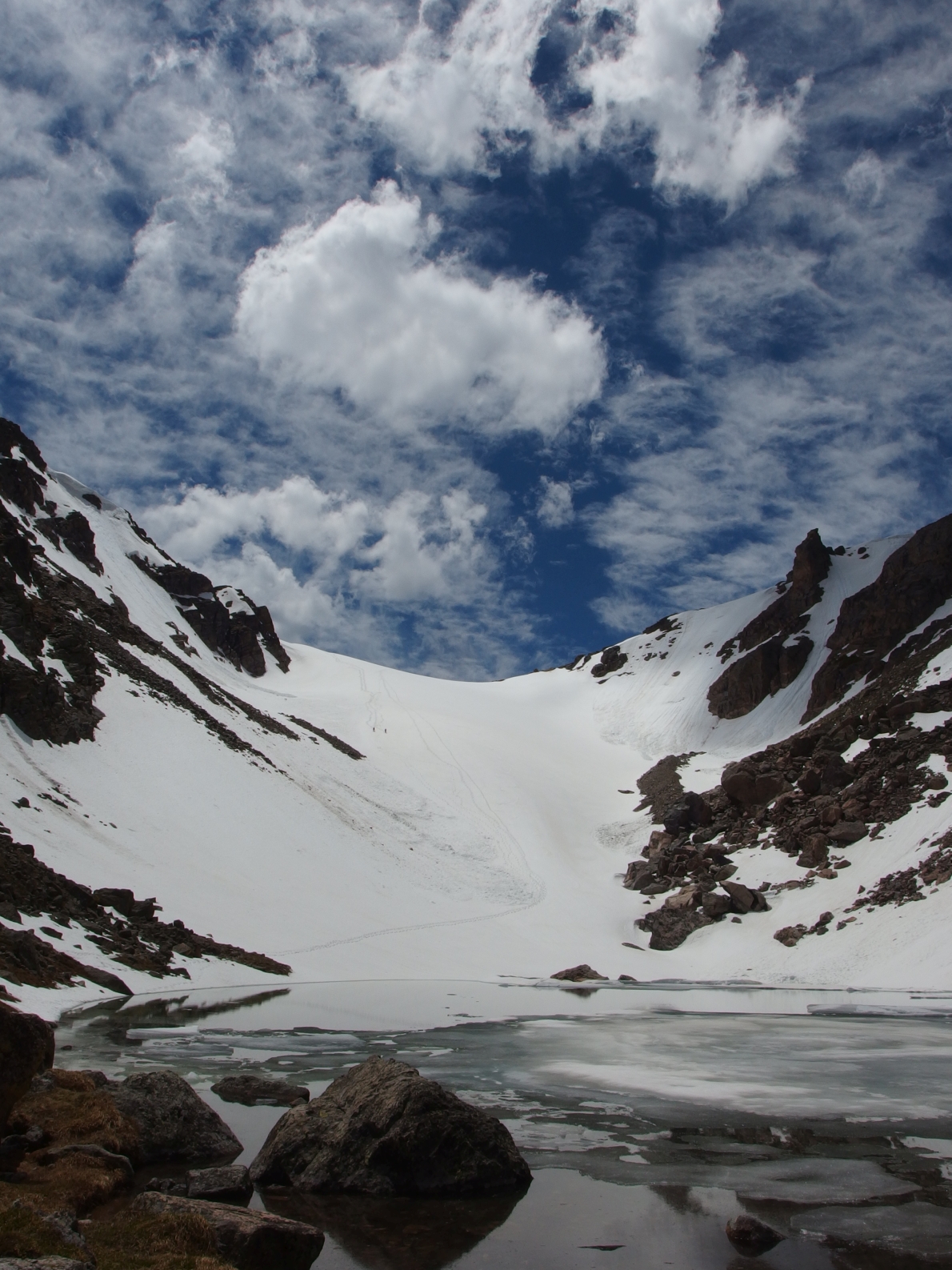
There was pretty consistent snow from the lake on up, and I generally tried to say on that.  I wore microspikes for this.  Things were firm and looking good.  Except for the lingering weather, hanging on the continental divide.  I was pretty far up the canyon before I was able to briefly see the glacier, and determine that there definitely wasn't a cornice at the top.
It's almost directly in the middle here, not that you can tell!
Some avalanche debris visible near the bottom.
I stopped at a rock before things got too steep and got geared up.  Helmet, crampons, ice axe, and just in case, an ice tool.  
The entrance to the glacier wasn't too bad, I'd say up until that rock band in the middle nothing more than moderate.  I took this photo from that band.
Here's what things looked like from that band.  Doesn't even look like 45 degrees here.
But all I had to do was look up to see that things were going to get steeper.  
From closer to the top, but still not at the steepest section.  
Looking down from there.
I definitely felt having a second tool added a sense of security, and I was able to move more confidently though the steeper stuff.
At the top.
The weather prediction was high of 49 and sunny.  Yep.  It was around 30, windy, and either gently precipitating, or blowing whatever had fallen the day before all around.  In other words, I was glad to have brought some colder weather gear, as I almost hadn't, and the day would have been pretty miserable without it.  As it was, I was right on the edge of discomfort.
Since everything was covered in a thin layer of ice, I put the microspikes back on.  From here I planned to summit Otis, and then go to Taylor before returning to and descending Andrews Glacier.  I'd already done the thing I came for, but figured some time at altitude working hard couldn't hurt.
Going up Otis.
Very close to the summit, which almost looks like being on another planet.  
At the summit of Otis Peak, 12,486 feet.
Now it was a short descent to Andrews Pass.  Since I wasn't going up and generating as much body heat, I felt a little chilly, again right on the edge of being cold.  But I was able to get below the cloudline, and while still quite windy, enjoy some sunshine and warm up a little at Andrews Pass.
This sign says something about how descending Andrews Glacier can be dangerous.  
Looks nice down there!
There is a small boulder at the pass, which was a nice wind block.  I put on the last layer I had, ate a snack, and shivered.  I wanted to go down, but Taylor Glacier was also something I intended to climb in this week, and I wanted to get a look at that.  Well, if the clouds broke.  I could not see the summit of Taylor from where I was.
Which made it look reasonably shorter.  This is one of those peaks that just doesn't seem to end.  It is less than a mile from Andrews Pass, but around 1200 feet of gain, so it takes some time. 
Sky Pond from Taylor Peak.
Taylor Peak summit cairn, June 14, 2016.
I headed down the other side for a short distance, and was able to catch a few glimpses of the Taylor Glacier through the clouds.  It was enough to tell me it looked good to go.  Well, steep and intimidating, but without a dangerous cornice at the top.
I headed back around Taylor, staying on snow almost the entire way down to the pass. 
The clouds briefly broke and I got to see Hallett for the first time this day.
Andrews Glacier was already pretty soft at ten thirty in the morning.  I had a nice glissade down some of it.  I was surprised to not see anyone at the tarn. 
But not surprised when I saw the slope below the tarn, which looks to be steeper than Andrews Glacier.
There was a fair amount of snow from here back to the trail to Sky Pond, and I lost the broken in trail.  No worries though, I just had to descend into the valley to pick up the trail.  From there, I started seeing the first people I'd see this day.  I took the Fire Trail down, but then had to take the trail back up from the Glacier Gorge intersection to Bear Lake.  I must've passed thirty people on this trail.  Bear Lake was teeming with people.  It's always strange to come back to that after being alone most of the day.
So, about that glacier.  I would say maximum of 50-60 degrees, which comes shortly before you reach the top.  To my eyes, the side to the right (north) looked slightly steeper than the side on the left.  It took me exactly 50 minutes to ascend from 11,350 feet, what I would consider the apron of the glacier, to the top at 12,040 feet, so we'll say 700 feet of climbing.  It really didn't feel too bad overall, but of course you must make sure you have the experience and equipment necessary to climb this glacier.  This would not be a good place to learn how to self arrest, and a fall could certainly result in serious injury or worse due to some of the lower rocky sections.  I found a second tool to be of great benefit while climbing.  I'd suggest late spring as a good time to go, as conditions were great and the snow coverage above Lake Haiyaha definitely made the approach alot easier.
There you have it internet world.  Some definitive information on climbing Chaotic Glacier.  Do with it as you will, have fun, and be safe out there!
Chaotic Glacier, Otis Peak, and Taylor Peak (distances as part of the loop):
Chaotic Glacier, 11,350-12,040 feet: 3.15 miles to apron, 2590 foot gain to top.  700 feet of climbing on 50-60 degree snow, AI2, second class.  Strenuous.*
Otis Peak, 12486 feet: 3.8 miles, 3036 foot gain.  Second class.  Moderate+.
Taylor Peak, 13153 feet: 5.3 miles, 3703 foot gain.  Second class.  Strenuous-.
As a whole, this hike covered approximately 10.6 miles with 4700 feet of elevation gain.  Strenuous.
*= Again, I will say this requires special equipment and skill.  Do not attempt this climb unless you have both. 

Wednesday, June 10, 2015

Powell Peak via Andrews Glacier.

I have had some great days outdoors this week.  Monday I got up to some higher altitudes for some fun mountain biking.  I found myself ripping downhill on ten inch wide single track through a meadow of wildflowers and wondered if life could get any better.  Well, I had to head to work after that, so no!  But it is those moments of perfection that I seek, where everything comes together even if only for a second.
I didn't sleep much that night since I had to close.  Bleary eyed to answer the 4:15 alarm, I slathered on sunscreen, put in my contacts, made some food, and started the drive up to Estes Park.  A few thoughts for the day had run through my head.  There are a few snow climbs I would like to accomplish this year.  But the look at the mountains from my highpoint on Monday told me it might still be too early for these.  So what to do?  
I started from the Glacier Gorge trail head at 6:15.  I took the Fire Trail both ways.  Alberta Falls is nice and all, but I've now seen it multiple times in every season.  
Working up to The Loch.  In the winter, you can just stay down in the valley.
The Loch was quite pretty, just as always.  I happened to make it up early enough on a low wind day and got a few nice reflective photos.  Directly ahead you can see the flat face of the peninsula of land that juts out from the Continental Divide and holds The Sharkstooth amongst other features.  To the left, find Sky Pond, and to the right you can see the top of Andrews Glacier.
Since I'd never been up here before, I somehow ended up staying on the mashed into the snow trail a little bit longer than I should.  The crampons were put on and I faced what would be the steepest snow climb of the day as I made my way uphill and into the basin holding Andrews Creek.
You can see some footprints here, and I could see footprints in places for most of the day.  Simply head up to reach Andrews Tarn.  I was feeling a little bit better heading up than I was last week.  Hopefully some of that fitness is coming back to me.  
I found the snow slope lying below Andrews Tarn to be steeper than the glacier itself, maybe 30+ degrees.  I stopped to take a picture of The Sharkstooth.  It looks pretty awesome sticking up by itself there.  Note the sliver of moon in the upper right corner.
I stopped at the tarn and had a snack.  There had been a little bit of slide activity on both sides of the glacier and I could see the footprints went around it.  Like always, it looked steeper and more imposing than it really was.  I felt I could have gone up in microspikes, but of course, better to be safe than sorry!
Contrary to earlier, I felt like I was dragging up the glacier.  The late turn cost me some time and energy.  All I could do was go at my pace.  In the end, I topped out the glacier about three hours and fifteen minutes after I left the car.
Taylor Peak loomed large.  All I could do was think about the last time I was here and how bad I felt then.  I started up, keeping the crampons on for the time being.  
Looking back at how much snow there is.  Fortunately, it is melting and consolidating, and largely held my body weight.  Postholing could have turned this day into a real slog.  The weather was great, with a nice cool wind blowing to offset my uphill energy.  I wore a tshirt the entire day.
I felt alot better ascending Taylor.  It is a little less than a mile from Andrews Pass and around 1200 feet of gain.  It offers some great views of Longs Peak.
Powell Peak still looked very far away.  I couldn't remember how far, or how much loss and gain would be needed to get there.  If I stayed close to the edge of the divide, I could stay on snow most of the way and minimize the elevation loss.  I started descending on talus and took off my crampons soon enough.  The traction simply was not needed on the snow and they were more of a hassle than an asset on the rock.
Taylor Glacier, Glass Lake.
I felt as though I was moving well, though again I was not going very quickly.  But I could finally see the summit of Powell Peak, with McHenrys and Longs in the background.  At some point during the hike, I realized that this could be my last ranked 13er in the park.  I ran through a mental list and found that it was indeed, with a few unranked points above 13k left to go, such as SE Longs and Glacier Ridge.
From what I could see from the summit, McHenrys Notch looked difficult but reasonable.  Once out of the notch, it looks like some easier terrain awaits to the summit, before entering some third class on the descent on the other side.  
Snow everywhere.  The Rabbit Hole Couloir of Mount Alice had been a thought for this week.  Maybe in another week or two, as there is still alot of snow up there.
I had a snack on the summit and planned to lounge around for a little bit.  That turned into a get packed and get going quickly when I heard thunder.  None of the clouds I could see looked threatening, but better to be on the safe side and head back.
I stopped at Andrews Pass for a snack and to trade the hiking poles for an ice axe.  I thought I heard voices, and looked up to Otis Peak, where I saw two people descending toward the pass.  We met up and talked.  It is always nice to run into people out there in what is essentially the middle of nowhere.  We shared some stories and took a few photos and were then on our way.  The descent was quick- I ran down and attempted to slide once, but the top layer of snow was so soft I could not get going.  Back at the tarn I looked up...
I thought these photos would turn out well, but this might be the single best series I have ever taken in the mountains.  Click to zoom in and find the two black dots on the upper left side of the glacier.  These are the two people I met descending.  
Seen here in close up.  
A pretty wonderful place to be!
I was able to glissade the slope below the tarn, and felt like I created a minor slide of my own as the top layer of snow was pretty slushy.  I stayed down in the basin and followed the footsteps down to get back to the trail in the right place.  As it turned out, the turn off wasn't obvious, but I still feel I shouldn't have missed it.  Ah well.
Back at The Loch I had a snack and reveled in another windless photo opportunity.  I started to see some people around The Loch, and passed a few on my way back down.  On the Fire Trail yet again, I enjoyed the quiet and solitude of the forest and thought about life for awhile.  Back on the official trail, I saw a few more people but avoided my favorite question- "How far?"
The trailside philosopher in me always wants to reply to that question by asking, "Does it matter?", but I usually give some time or distance guess, or the vague, "You're getting there", or something of that sort.
I got back to the car at precisely 3:36, giving me nine hours and twenty one minutes to do this hike.  I loved every second of it.  Despite only sleeping four and a half hours the night before, I felt rather chipper.  'If only I had my running shoes,' I thought.  'And more water.'  'And a big plate of food.'
The drive back home was uneventful and punctuated with a trip to the grocery store.  Not five hours before I had been lounging in sunshine at 13208 feet.  Life was perfect for a few hours.
All in, this is not a very technically difficult hike.  Andrews Glacier is pretty mellow in grade, though it should be noted it can still form crevasses, and as it terminates into frigid water, a uncontrolled slide down could result in a potentially life threatening situation.  Thus I would recommend the usage of an ice axe or hiking poles as an aid to control the speed of your descent.  Taylor and Powell are no more than second class on grass and scree in the summer months, or some combination of those and snow in winter.
Powell Peak is named for John Wesley Powell, an early explorer of the west.
Link to hike map on Caltopo.
Powell Peak via Andrews Glacier (all distances measured using the Fire Trail, add about a mile if not):
The Loch, 10190 feet: 1.7 miles each way, 1040 foot elevation gain.  Moderate.
Andrews Tarn, 11390 feet: 3.3 miles each way, 2150 foot gain.  Moderate+.
Andrews Glacier, 11650 feet (approximately the middle): 3.6 miles one way, 2410 foot gain.  Moderate+
Andrews Pass, 11980 feet: 3.8 miles one way, 2740 foot gain.  Moderate+.
Taylor Peak, 13153 feet: 4.7 miles one way, 3913 foot gain.  Strenuous-.
Powell Peak, 13208 feet: 6.1 miles one way, 3968 foot gain.  Strenuous-.
As a whole, this hike covered approximately 12 miles with 4800 feet of gross elevation gain.  Strenuous.