Showing posts with label mt meeker. Show all posts

Friday, July 31, 2015

The Loft, Mt. Meeker, SE Longs, Ships Prow, and Glacier Ridge.

Earlier in the week I got a message from a friend I hadn't seen in awhile.  Her family was out of town for the week and she was staying at the Glacier Basin Campground, and wanted some ideas for shorter outings in RMNP.  Of course, I'd already spent some time thinking about what I could do.  I wasn't able to get out on my normal days off, but I'd thought I could get out on Thursday before work.  I suggested that we meet up dark and early at the Longs Peak TH, and go to Chasm Lake.  Thus it was decided.  
The 2am alarm went off, and despite feeling as though I didn't ever get to full sleep, I felt somewhat chipper as I started to get ready.  I was out the door shortly after 2:30, with plenty of time to make our 3:30 rendezvous.  A car was behind me all the way up, and I thought they must either live somewhere up in the area or be going exactly where I was.  They turned toward the trail head, just as I did.
The parking lot was surprisingly full for 3:30 on a Thursday morning, yet the weather forecast was perfect for the day.  I got ready and waited for a few minutes until she showed up, saying she thought she got the last legal parking space!
Up we went by headlamp, occasionally seeing flashes of light through the forest of those ahead of us.  We set a good conversational pace on the way up, and passed a few people on the way.  It was really nice to hike with someone.  It's been awhile, and I really enjoyed the company.
We made it to Chasm Junction around 5:20.  The headlamps came off and the sky was growing quite light.  Along the Chasm Lake trail we looked back and saw the sun start to just peek over the horizon.  We made it to the lake for the last few minutes of Alpenglow, and enjoyed sunrise together. 
It's worth getting up early once in awhile.  There will only be so many sunrises in life shared with a friend.
From here, we bid each other farewell, and she headed back down to make a 9am conference call.  I could see that my planned ascent route looked snowy, perhaps to the point of not being ascendable at all.  I briefly considered going for the Iron Gates route instead, but that would considerably lengthen the day and I had to be in Boulder by 2pm for work.  I decided to just go check it out.
There was indeed too much snow to ascend the standard Loft route, but I was able to stay on slabbly rock to the climbers left heading up.  I found the exit ramp that cuts left just before the way up gets really steep.  
When you see these often wet and steeper rocks, go left!
I thought the way up from here was relatively easy to follow.  Look for the usual cairns and wear on the ground.  At one point, a huge boulder will block the way forward.  You can scramble around its left for LOTS of exposure, climb up directly on the right of it, or turn around and take the thin ramp up to avoid it completely.
I had planned to maybe add Mt. Meeker on, possibly at the end of my time at altitude, but the route seemed to exit pretty close to it.  A quick decision was made, and I stayed on a thin trail to get close to the summit, and then scrambled a bit to stand atop Mt. Meeker for the second time
Longs from Meeker.  I could see tiny figures on top, and hear the sporadic yells of joy when the summit was reached.  I wouldn't let out a cry until I was safely back on more solid ground.
For reference, it took me about an hour and thirty five minutes to go from Chasm Lake to Meeker.  Not bad.
I've also climbed Meeker from the Horse Creek TH, and have done Meeker Ridge from the same place.  I would have to say I felt the Horse Creek route to be more difficult, with more elevation gain, and much more route finding and bushwhacking below treeline.  
Back down to The Loft and Chasm Junction.
I headed back down to The Loft and towards Southeast Longs, aka The Beaver.  I made great time on the thin trail, and then found some talus on the way to the summit.
Longs Peak from Southeast Longs.  It took me about fifty minutes to get here from Meeker.  
Rappel bolt on the summit.
Looking back to Meeker.
And a crazy view back down to Chasm Lake.
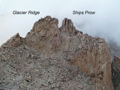
My next goals were Ships Prow Tower and Glacier Ridge.  These are some interesting high points, briefly touched upon in Fosters book.  Glacier Ridge is briefly mentioned on page 242, and given "all aspects are technical".  Ships Prow Tower is also talked about, and referred to as technical only.  However, she places them in different spots than LOJ does.
Ships Prow is the rock formation that extends northeast from The Loft and looks a whole lot like a ships prow from below.  As stated in this great (and confidence inspiring) trip report by JM Brooks, where is the high point?  LOJ marks the summit as the NE closed contour loop at the top of the formation.  Foster chooses the SW closed loop as the summit of Ships Prow (photo page 225), without giving a specific location to Glacier Ridge.  This summit is slightly higher in elevation, and called Glacier Ridge on LOJ.
Glacier Ridge is given an easier technical rating on LOJ, 5.2 vs 5.4 for Ships Prow.  But the referenced trip report talks about a third class route up Ships Prow, and suggests Glacier Ridge could be as difficult as 5.4 with the possibility of a 4th class route.
Got it?
Hopefully that will help a little bit.  I also neglected to take a good photo of these high points from The Loft, please click here for a photo that accompanies the trip report.  For our purposes, I will use the LOJ names for the remainder of this report.
As suggested by both Foster and Brooks, I skirted the SW tower on the NW to head into the gully that leads to a saddle between the two high points.  I wanted to check out the third class route suggested by Brooks to be on the NE side of Ships Prow.  I worked my way over blocky rock and huge exposure to arrive at a thin ridge that lead directly to the summit.  I started along this, but the wind, exposure, and what looked like an easier route on the other side quickly convinced me to drop down and check it out.  There were some loose blocs in this area, so use caution and make sure to test hand and foot holds before committing to full body weight.
The route went, and in short order I was on top of this tiny summit.  It was exposed enough that I didn't want to take my pack off and get my camera out, so I headed back down.  This point has a whopping 7 registered summits on LOJ, and no register.
This is the third class route from lower on.  Major exposure all around.  I agree with Brooks' rating of 3+ here.
I crossed back over the ridge and headed back to the saddle between the high points.  I would just take a look at the suggested 5.2-4 route and see what things looked like.
Approaching the saddle, Glacier Ridge on the right.  I made my way up toward the top, but exited right into the prominent V shape with loose looking blocs in it.  I found these stable and made a few moves to work up and to the right onto some easier ground.
How hard was it?  Very difficult to say.  It was definitely climbing, but the holds were good.  I made one large step up with my right foot.  I never felt like there was a chance of falling.  I honestly don't know if I could tell the difference between a 5.2 and a 5.4.
There was a piece of cord left as a rappel anchor around a large rock on the summit, and a Grey Poupon jar served as a register placed by Mike Garrett in 2003 and proclaiming "Ships Prow/Glacier Ridge, 13340'".  That probably only adds to the confusion!  The register was well intact, and I added my name, the address of this blog, and a short message to a friend now gone.  The register had last been signed in 2012, and was not very populated.  This point has 10 registered summits on LOJ.
A unique view of Longs from Glacier Ridge.
Now it was time to get down.  In the name of exploration, I decided to head directly towards The Loft and see what things looked like.  After all, this is the face you see from up there, and as I got closer to it, I felt it didn't look too bad, with one big step up/down move.  I got to a point where I could see down.  Things looked good, and I went for it.
Again, how hard was it?  At least 4th class, and it felt easier than the way I'd taken up, but still had definitive climbing moves.  The feet were better, but the hands were worse.  So 4+ to low fifth we'll say.
Glacier Ridge as seen from The Loft, and the route I down climbed.
I was now on less technical ground (for the time being!), and finally let out my own excited yell.  While the technical difficulties don't last for long, these points are without question two of the most exposed and difficult summits to reach in the whole of RMNP. 
But I still had to go back down this.... and it looks very steep from up here.
I contoured around to get back to the proper place to get into the route down from The Loft.  There are cairns marking it, but as always, if you were to come up this way and planning to go back down the same route, make sure to take some mental photographs of the area so you can refind the proper place to start down.
Going down was no more difficult than heading up, with the route finding being pretty mellow.  Until I hit the slabby rock that is.  Usually I find it easier to head down things as you can generally see what route you should take from above, but here that was not the case.  It took a little exploration at times, but I finally made it to the loose talus marking the bottom of the couloir. 
In The Loft heading down.
I got back to the trail and was able to start moving a bit more quickly.  Once I hit tree line I started jogging.  I felt like I was making great time until a real trail runner blazed by me on the descent!  Oh well, I do what I can.  I got back to the car shortly after 12, giving me just over 10 hours to do this hike, and plenty of time to get to work on time.  And of course, by the time I got to work on this day I'd already been awake for 12 hours, which made the day more fun!
I say this about ever hike I do, but this was truly a great day.  It was awesome to spend some time with a friend I haven't seen in ages, get to a few new fun and adventurous destinations, and to get to remember a fallen friend at one of those.  Mount Meeker is a must do in my opinion.  SE Longs is a unique point to visit, so close to the actual summit, yet so far away.  Glacier Ridge and Ships Prow are pretty fun in my book, but make sure your ability level is up for the challenge.  These points are amongst the most difficult in RMNP.
The Loft, Mt. Meeker, SE Longs, Ships Prow, and Glacier Ridge:
Chasm Lake, 11780 feet: 4.2 miles one way, 2380 foot gain.  Moderate+.
The Loft, 13460 feet: 5.2 miles one way, 4060 foot gain.  Third class.  Strenuous.
Mount Meeker, 13911 feet: 5.45 miles one way, 4511 foot gain.  Third class.  Strenuous.
Southeast Longs, 14060 feet: 5.5 miles one way, 4660 foot gain.  Third class.  Strenuous.
Ships Prow, 13340 feet: 5.2 miles one way, 3940 foot gain.  Third class + to 5.4.  Strenuous+.*
Glacier Ridge, 13340 feet: 5.2 miles one way, 3940 foot gain.  Fourth class + to 5.4.  Strenuous+.*
Along the way you will also pass:
Chasm Meadows, 11599 feet: 4 miles one way, 2199 foot gain.  Moderate+.
Columbine Falls, 11440 feet: 3.9 miles one way, 2040 foot gain.  Moderate+.
*To explain my thoughts on these points of interest, I feel even though these are closer to the trailhead and do not have as much elevation gain as Meeker or SE Longs, these definitely have a much increased technical difficulty over either of those, and are therefore more difficult overall.  Yes, The Loft route itself is third class, but it is well cairned and pretty worn in at places.  Don't expect any cairns en route to the third class access to Ships Prow.

In loving memory of Liberty Rebekah Dagenais.  October 9, 1980- July 22, 2010. 

Sunday, January 20, 2013

Mt. Lady Washington in the winter.

Well, I have finally found my own transportation besides a motorcycle, which means I should be able to get out alot more in the next year.  This week I did something on my list as a bit of a winter warm up.  It seemed appropriate since we are in a winter warm up of our own here, with temperatures predicted to top out at 65 degrees this week.
Mt. Lady Washington is in the Longs Peak group, and was on my radar for something to do in the winter since I knew it would not be technical and there is little to no risk of avalanche.
I arrived at the Longs Peak TH shortly after seven am, the only vehicle in the parking lot.  It was warmer than I expected, and it took me a little bit of time to get situated as far as clothing and traction devices in the first mile or so. 
Twin Sisters as seen from the trail.
The trail is in great shape, completely packed at this point and well delineated.
Reaching tree line, and a sign that I have never seen before.
Twin Sisters proved to be easy to see and very photogenic throughout the day. 
Tree line being passed, and my goal seen along with Mt. Meeker and Longs Peak.
I was able to follow the trail for the most part, though things got a bit difficult to see here and there with the blown snow.  But since I was able to see where I was going quite well, there were no troubles. 
I eventually broke from the trail and started up the east ridge of the mountain.
Increasingly good views of Longs.
Points north east.
It took me quite a while to scramble up the ridge.  Of course with snow and ice, it is important to take your time!
Ships Prow looming!  A pretty cool view!
Finally arriving at the summit.  The view of Longs as you crest the peak is simply amazing!  The Diamond is one of Colorados most iconic images, and you get an up close view.
Mount Meeker.
Second highest and highest peaks in the park!

Very back lit, but on the top and loving it!

Storm Peak and some others for the future.
Mummy Range.
At this point, I was thinking about adding on Storm Peak.  It didn't look too far away.  But when I took a look at the clock, I knew it would have to wait for another day. 
Back east with Twin Sisters now looking tiny.
The Diamond.
A panorama which does not do the view justice.
Chasm Lake frozen well below.
I decided to descend the western slope, just for comparisons sake.  I found it to be a bit snowier and therefore slipperier.  I noticed the keyhole, part of the most popular route to climb Longs.  Note the Agnes Vaille hut just to the left of the keyhole.
Not zoomed in.  The boulderfield was a little deceptively named.  More like small pieces of talus field.  That has a certain ring to it!
Storm Peak from the boulderfield.
Looking up the west slope of Mt. Lady Washington.
The low clouds...
...played with these peaks all day.

Sunshine highlights the ridge I had hiked up just hours before.
Twin Sisters.
A neat windblown snow sculpture.  The compressed snow under someones feet has stayed in place, with the loose snow blowing away.
About this time I was cursing my decision to bring snow shoes.  I had not used them at all, and had drug the extra weight all the way up there with me.  My opportunity was soon to come as I lost the trail going back below tree line, and followed someone elses footprints for a bit before becoming immersed in deep powder.  I strapped them on and wandered for a bit, eventually stopping to look closely at a map.
I decided where I most likely was, where the trail should be, and made my way.  It was about 200 feet away from me.
From here it was just a motor back down to the trail head.  I did see one other person on their way down as well, but that was it for the day.
All in all, this is an awesome hike to do any time of the year.  Traffic will probably keep the snow fairly well compacted, so I doubt you'd need snow shoes unless it just snowed the night before.  The view when you arrive at the top is awesome- Longs looms huge and you can get a very good idea of just exactly how big it is.
Mt. Lady Washington in the Winter:
4.2 miles via east ridge, 6.3 via west ridge, 3881 foot gain.  Second class.  Strenuous-.

Wednesday, October 31, 2012

Meeker Ridge via Horse Creek Trailhead.

A few weeks ago I set out early one morning with Dan.  Our goal was to do Meeker and Longs in one day.  Unfortunately, that did not happen, and we didn't even end up summiting Meeker.
We met up in Lyons pretty early, and started from the Horse Creek trailhead.  Though there has not been much snow as of yet this year, I could see snow up there from my house, and we felt like this route had the best chance of being snow free or nearly so.
We were hiking for several hours and just making our way to tree line when the sun started to rise. 
Pretty neat to see the lights of the cities laid out beneath us.
A large cairn above treeline on Meeker ridge. 
I am not sure why, but I was feeling horrible.  My stomach hurt, legs hurt, lungs felt like they just couldn't get enough air.  I felt very nauseous as well, which doesn't help when you are doing a fairly strenuous exercise and need to eat throughout the day.  Every time I did eat something I felt like I was going to throw up.
But we pushed on, here gaining sight of Meeker from the ridge.
Looking south to Wild Basin.  Snow capped peaks.
The weather prediction called for wind, and it did not disappoint.  We eventually moved to the north side of the ridge even though the going was harder just to be out of it.
The day looks so beautiful, but with 40+ mph sustained winds and higher gusts, it got alot less fun.
The peaks of Wild Basin from the summit of Meeker Ridge, which at 13871 feet, is some 40 feet lower than the true western summit at 13911.
The ridge between the east and west summits is about 300 yards of highly exposed third class.  A place you definitely don't want to fall.  Note Longs Peak in the background.  With the wind ripping, we wisely decided to head back without gaining the true summit.
A feature called Ships Prow extends northeast from the Longs area.
On the way back down it was so damn windy.  I was following Dan and we looked like two drunk people struggling to stay upright.  There were times the wind was so fierce, all I could do was crouch down as quickly as possible to avoid getting blown over.   Still looks pretty though...
Again we crossed back to the north side of the ridge to get out of the wind.  It didn't always work, like when I stopped to pee and yeah.  It was like the scene in The Big Lebowski where they spread Donnies ashes, except instead of ashes in my face it was my own pee.  What fun.
We decided to go back over into the wind when it looked like we were getting to a tower we'd have to descend.  Dan went first while I gave myself a golden shower.  When I topped the ridge and stood up, a gust of wind hit me so hard it actually blew me back off my feet, causing me to fall and hit my left knee quite hard on a rock.  And in exactly the same place I had hit it descending a snow field during the Eagles Beak hike.
Immediate and intense pain flooded through me, and I thought I had broken my leg at first.  I hobbled and caught up to Dan and took a seat to assess the damage.  Didn't think it was broken, but it sure hurt alot.  Took some Advil, got out my ice axe and used that as a cane for most of the rest of the day. 
Once we got back to tree line, we lost the cairned unofficial trail back down and ended up somewhere north of it.  We eventually just decided to head for the south side of Horsetooth and know that we'd run into the trail eventually.  It was a great feeling when we did.  By now the pain meds had kicked in and I made the rest of the hike down feeling fine.  I was quite sore the next day however, and it has taken several weeks for it to go back to feeling almost normal.
Here is a look back as the trail crosses Horse Creek and starts to gain elevation.  It is only a few minutes back to the car from here. 
I am not sure why I felt so bad.  Everyone has off days I guess, and it was pretty good when I started feeling as though I could eat, but I think the hours of not eating anything certainly didn't help at all.  And we learned that this would be a good hike to avoid when the forecast calls for wind!
I guess the Meeker/Longs combo will have to wait for another day- probably next year.  We did discuss difficulty, since I had heard from someone else that he felt Meeker was more difficult than Longs.  When done this way, you do more elevation gain over a shorter distance, the class three is more exposed, and definite trail finding skills are needed.  Meeker is often overlooked being so close to Longs, but if you have done Longs already, try Meeker next year.  It is a rewarding peak to climb.
Meeker Ridge via Horse Creek trail head:
5 miles one way, 5171 foot gain. Some second class. Strenuous+.