With not great weather predicted for this week, I decided to spend another day safely below treeline. I would take on some of the peaks listed in the "Eastern Perimeter" section of
Fosters book, none of which are actually in RMNP, but nonetheless, provide captivating views of the park and the larger Estes area.
I won't name the first peak of the day, but I'm sure you can figure it out with a little research...
Pre-dawn view from the top of Mount ??????.
The summit of said peak.
This provided a fun and short scramble up to the top. I was up and down in 36 minutes.
From here, I headed to the next goal of the day. This peak is one that is overlooked in the area, perhaps because it is only 8808 feet in elevation. But it is the place that a man named
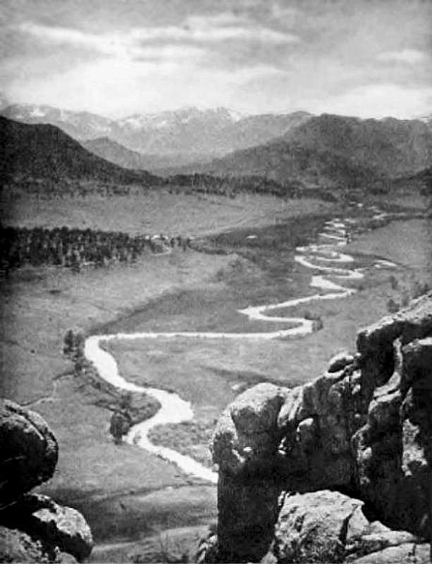
Enos Mills took this spectacular photograph from....
This is a view of
the Estes Valley taken from Mount Olympus in 1909. Things sure have
changed.....
From the summit in 2016. But how to get there?
Find this small pull out off of 34 (40.442401, -105.378370). It's on the right side when you're headed down from Estes to Loveland. Note the National Forest sign. It's about 3 miles outside of Estes Park.
From the parking, look for this steep "trail". There isn't really much of a trail, and the travel is bushwhacky. I did find some cairns along the way, but not enough to mark a distinct route. I tried to stay on a rock rib most of the way up.
Here is one of those cairns.
A small meadow with a view down to Lake Estes.
An interesting face in the rock near the summit.
Right at the top.
Unbeknownst to me at the time, the summit of this peak lies on private property. However, this summit gets a fair amount of visitation, and since the property lies in the valley on the other side, I'd say the risk of getting caught here is minimal. And you could always claim ignorance, as I would have.
Looking south to Mount Pisgah,
Kruger Rock, and others....
I signed the register, and set my sights to Noel's Knob. This 8460 foot summit is unranked, and not in Fosters book, but while I was in the area I decided to take a look.
Noel's Knob from Mount Olympus. I read on LoJ that this peak was anywhere from 5.0 to 5.4.
The bushwhack continued as I approached the peak. At the base, I circled around, trying to determine the easiest way to the top. I'd read the eastern side held the 5.0 approach, but it looked a little slabby, and as though there might be a notch along the way. The south side was too steep, as was the north. The west side looked slabby. The the northwest approach, described
here by Brian Crim, looked pretty solid at 5.4.
This route ultimately proved to be the key to unlocking the summit. I felt the hardest moves were the first few, just getting off the ground. From there it was some easier scrambling interspersed with some climbing.
The route I took up and down. I found the remains of a sling that wasn't slung to anything, and packed that out.
The summit register was in poor shape. I wish I'd read Brian's tr a bit better, because I could have brought a new jar along. It was open to the elements, with the paper inside looking moldy, and no writing implements in view. If you go, a completely new register might be in order.
Mount Olympus from Noel's Knob.
Looking back down the ascent route- I went exactly the same way down as up. This was a fun little summit, and certainly worth the time and trouble to get there if you have the skill to climb to the top.
I descended towards Olympus until I hit a dirt road. I turned right on that and stayed on it for a short time before heading off onto a bushwhacky contour around Mount Olympus. This was the most intense bushwhacking of the day, with fallen timber and thick undergrowth. Some rock prevented easy movement here and there. But I eventually made it back to the car.
This leg of the hike took me longer than I thought it would, but I was still back at the car reasonably early in the day. Onto the next leg!
I continued down 34 until I got to Drake. I turned left onto 43, and drove about 2.1 miles up to find the Garden Gate trailhead on the left side of the road. Well, I drove by it the first time because I thought there would be a sign or something. It's just a dirt pullout, with a trail going through a fence. Here is what it looks like....
There is parking for several vehicles. There is a sign up the trail a short ways, but nothing here. My goal here was the high point of the day, the 9250 foot Crosier Mountain. While in the area, I also planned to visit West Crosier, 7778, and Sullivan Point. Again, these are not in Fosters book, but close enough to where I was that it made sense to just put in a little extra effort now, rather than come back in the future.
This mine shaft lies right off the trail pretty close to the start.
The trail offers pleasant hiking through pine forests and rock. Despite the relatively low altitude of the summit, I knew it wouldn't be too easy- you start at around 6400 feet, so there's nearly 3000 feet of gain over ~5 miles.
Interesting texture of tree bark.
Almost there!
As I approached the summit, I found the register wasn't actually on top of the peak, but stashed near a tree. I signed in and took a break.
The true summit.
From Crosier, I headed nw and then finally cut west to get to West Crosier. This brought some slabby, rocky terrain, but the navigation wasn't too bad. Once in the saddle between the two peaks, simply head up over some dead fall. The summit comes soon enough.
West Crosier, 9020 feet. There was a small old rusty can on top of the cairn that had some extremely fragile paper in it- there was nothing written on it that I could tell.
I found the neat remnants of a tree on descent.
This fence and gate marks some private property that lies between the peaks.
Going back up Crosier was a bit of a challenge. I thought it was actually worse than heading down. I eventually got to a point where I was stuck, and had to traverse to an easier gully.
West Crosier and clouds.
A great view of RMNP from the resummit of Crosier.
The bench mark on top of Crosier.
Heading back down was easy enough, though the trail is quite rocky in places.
A pleasant meadow on descent.
At this point, I was feeling pretty tired and my motivation to continue on to 7778 and Sullivan Point was low. But as always, I did the math and decided that an hour and a little bit to go out and back was ultimately easier than spending a whole day to come back up and visit these points. Thus, I turned off from the Crosier trail at an appropriate place, and aimed towards these points.
While the topos show a trail from Sullivan Gulch that connects with the Crosier trail, I didn't find any evidence of it, despite apparently being quite close to it. I did find a thin, matted grass trail when I got closer to these two points.
7778 from Sullivan Point.
There is some debate here, as one of these peaks is ranked, which means the shorter one wouldn't be. 7778 gets the nod on LoJ, and has been measured by someone there and estimated to be several feet higher. Another person noted that they found a register on Sullivan Point (I did not), but not on 7778. But by interpolation, the elevation of Sullivan Point is 7780. I used my phone and GPS device to take a measurement on both peaks. At Sullivan Point I got 7769 and 7773, which rounds out to be 7771. On 7778, I got 7772 and 7784, which rounds to..... 7778! Thus, I would say that 7778 is the ranked peak, and Sullivan Point is not. This is in line with what others have found.
Sullivan Point summit.
Looking back to Sullivan Point from 7778.
The summit of 7778.
Which ever is higher, both provided fun but short scrambles to the summits.
I headed back down on the matted grass trail, which crossed another trail and continued up. I followed the up for a short time before the trail seemed to end, and then turned north and slightly west to get back to the Crosier trail.
Brooding weather....
Cacti along the way. I did see a cairn or two, but no real signs of a trail at all. However, I was largely in meadow and grassy areas, so the going was pretty easy.
Looking back to Sullivan Point (L) and 7778 (R).
Back on the trail as the evening started to come.
Close to the trailhead, and close to nightfall.
I made most of the drive back in darkness feeling a little tired. I think some overlook these lower peaks in favor of 14ers. I love them all, and enjoy days like this. All in, I covered 23.47 miles with 8501 feet of elevation gain without ever breaking treeline or going higher than the 9250 foot summit of Crosier Mountain. I saw one person all day, and, with a few short drives in between, spent all day- sunrise to sunset- in the mountains.
Peakbagging the Eastern Perimeter of RMNP (distances as part of each segment of the hike):
Mount ??????, 8630 feet: 1.38 miles roundtrip, 886 foot gain. Third class. Moderate-.*
Mount Olympus area:
Mount Olympus, 8808 feet: 1.15 miles, 1503 foot gain. Second class. Moderate.
Noel's Knob, 8460 feet: 2.64 miles, 1105 foot gain. 5.4. Moderate+.
This leg of the hike covered 5.12 miles with 2067 feet of elevation gain with plenty of bushwhacking and movement in up to 5.4 terrain. Moderate+.
Crosier Mountain area:
Crosier Mountain, 9250 feet: 5.75 miles, 2635 foot gain. Second class. Moderate+.
West Crosier, 9020 feet: 6.8 miles, 2605 foot gain. Second class**. Moderate+.
Sullivan Point, 7771 feet:13.8 miles, 1356 foot gain. Third class. Moderate.
7778: 14.15 miles, 1363 foot gain. Third class. Moderate.
This leg of the hike covered 16.93 miles with 5548 feet of elevation gain in up to third class terrain. Strenuous-.
*= Again, this peak lies on private property, and the owners are apparently not open to sharing it with anyone. Climb at your own risk.
**= While second class from the saddle, you may find some more difficult movement when descending Crosier Mountain.